Quick summary for busy readers
GPR performs best in low‑conductivity, dry, and homogeneous soils such as dry sands, gravels, and frozen ground. It struggles in high‑conductivity, clay‑rich, saline, or mineralized soils because those conditions absorb or scatter radar energy. Choose antenna frequency to match target size and depth: higher frequency for shallow detail, lower frequency for deeper penetration. Always run calibration lines, use multiple frequencies when possible, and combine GPR with EM locators, sondes, resistivity, or vacuum excavation for verification. Schedule surveys in drier seasons and document soil moisture and recent precipitation. Contact us if you want to schedule a service or want a free quote.
Table of contents
- Introduction and core principles
- How GPR works (physics made practical)
- Soil and subsurface properties that control GPR performance
- Antenna frequency, depth, and resolution strategy
- Regional guidance across the United States (expanded)
- Pre‑survey planning and desk research
- Field workflow and data collection best practices
- Processing and Interpreting GPR Data Across Different U.S. Soil Conditions
- Essential GPR Equipment, Software Tools, and Field Safety Best Practices
- Conclusion and next steps
Introduction and core principles
Ground Penetrating Radar (GPR) has completely transformed how we map the world beneath our feet. Whether you are working in construction, utility locating, or archaeology, this technology offers incredible, non-invasive insights. However, because GPR relies on electromagnetic waves, the environment directly dictates how well it performs. From the sandy soils of the Atlantic Coast to the dense, conductive clays of the American Midwest, results can vary drastically.
In this guide, we will walk through the fundamentals of GPR, explain why your specific soil type is the most critical variable in your survey, and show you how to master your results regardless of the ground conditions.
How GPR works: physics made practical
Think of Ground Penetrating Radar (GPR) as a smart, non-destructive way to “see” what’s underground. It works like a high-tech echo system: a transmitter sends high-frequency radio waves into the ground, and when those waves hit something different (like a buried utility, a void, or a change in soil), they bounce back to a receiver. By measuring how long those signals take to return, GPR software creates accurate, real-time underground maps without any digging.
To get the most accurate results, it’s important to calibrate the signal velocity using known reference points like manholes, exposed pipes, or sondes. Because soil conditions and moisture levels can change how fast signals travel, proper calibration helps reduce depth errors and improves the accuracy of your utility locating data.
Here are a few key things to keep in mind:
- Stronger reflections usually mean a bigger contrast in materials, metal objects, and air-filled voids tend to stand out clearly.
- Signal travel time is what we use to calculate depth, based on the measured ground velocity.
- Amplitude and continuity help distinguish real utilities from background noise or clutter.
- Using multiple frequencies allows you to capture both shallow detail and deeper subsurface structures.
In this guide, we’ll break down the fundamentals of GPR, explain how soil conditions impact your results, and show you how to improve accuracy and confidence in any subsurface utility survey.
Why Soil Type Matters for GPR Performance
It is important to remember that GPR is not a “one size fits all” tool. Since radar waves are electromagnetic, the soil composition acts as the gatekeeper for those signals. Ideally, you want to work in highly resistive materials, such as dry sand or solid rock, which allow waves to travel easily. Conversely, many regions across the U.S. contain soils with high moisture, salt, or clay content. These tricky conditions act like a “sponge,” absorbing or scattering your radar energy before it ever reaches your target. Because of this, understanding your local soil is the secret to planning a successful survey. You need to examinate some key elements like:
Conductivity
Conductivity directly affects how deep ground-penetrating radar (GPR) can see by controlling energy loss.
High-conductivity soils: wet clay, saline ground, or mineral-rich areas, radar energy attenuates quickly, reducing penetration depth.
Low-conductivity soils: sand, gravel, and frozen ground allow signals to travel farther, producing clearer and deeper subsurface images.
Dielectric Constant (Permittivity)
The dielectric constant determines how fast radar waves move through the ground. For example, water significantly increases permittivity, which slows wave speed and changes how depth is calculated. As a result, differences in permittivity between soil layers create the reflections used to identify underground features.
Moisture Content
Moisture plays a major role in GPR performance because it increases both permittivity and conductivity. For instance, a site that produces clear results during dry summer conditions may become much harder to interpret after heavy rainfall. For this reason, it’s important to track recent weather conditions and groundwater levels before surveying.
Soil Heterogeneity and Layering
Soils with mixed materials (such as fill dirt, glacial till, volcanic deposits, or engineered layers) tend to scatter radar energy. This creates signal noise and clutter in the data. Therefore, heterogeneous ground conditions often require tighter line spacing and multiple crossing survey lines to improve accuracy and confidence in interpretation.
Mineralization and Salinity
High levels of minerals and saline groundwater increase conductivity, which weakens radar signals and reduces depth capability. As a result, GPR performance is often limited in environments such as coastal zones, salt marshes, and mineral-rich mining areas.
Hard Horizons
Dense layers like caliche, hardpan, or shallow bedrock produce strong reflections that can hide deeper targets or create multiple signal echoes. To improve interpretation, it’s best to identify these horizons early so you can set realistic expectations for survey depth and clarity.
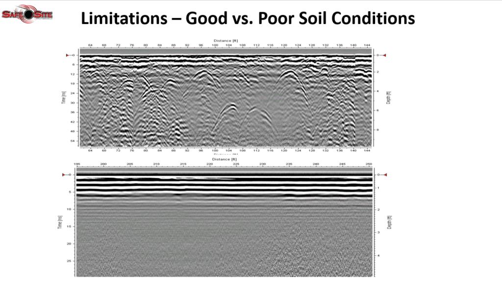
In this graphic created by Safe Site, you can see how GPR radar waves scan the ground and respond differently depending on soil conditions, helping visualize how subsurface detection changes from one environment to another.
Antenna frequency, depth, and resolution strategy
Choosing the right antenna frequency is one of the most important decisions in ground penetrating radar (GPR) surveying, and it directly impacts data quality, depth, and resolution.
High-frequency antennas (900–2700 MHz) work best when you need sharp detail at shallow depths. For example, they are ideal for detecting rebar, conduits, and shallow utilities in dense urban environments. Although they deliver excellent resolution, they offer limited penetration depth, so they are best for near-surface targets.
In contrast, mid-frequency antennas (400–900 MHz) provide a balanced approach. They allow you to capture both depth and detail, making them a strong choice for suburban utility locating and general infrastructure inspections. Because of this flexibility, they are often the go-to option for mixed survey conditions.
Meanwhile, low-frequency antennas (100–400 MHz and below) penetrate much deeper into the subsurface. As a result, they are best suited for deep geological investigations, large underground tanks, and void detection. However, this increased depth comes with reduced image detail.
To optimize results, we at Safe Site recommend a practical, layered strategy. Whenever possible, collect data using at least two frequencies to improve accuracy and confidence. Start with a mid-frequency sweep to identify targets quickly, then switch to high frequency for detailed mapping and low frequency to confirm deeper features. Additionally, in noisy soils or complex environments, tighten line spacing to improve detection of small or discontinuous targets.
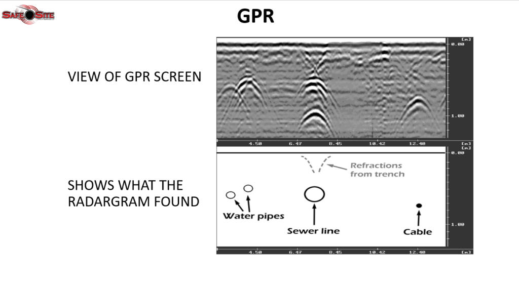
In this graphic created by Safe Site, the top image shows how the GPR screen displays the detected subsurface features. Based on that scan, the bottom image interprets the results, showing two water pipes on the left, a sewer line in the center, and a cable line on the right.
Regional guidance across the United States
GPR performance can vary significantly across the U.S. due to differences in soil type, moisture, geology, and urban infrastructure.
Understanding these regional conditions is key to setting realistic expectations and choosing the right survey approach.
It’s time to break down each major region to help you plan more accurate and efficient subsurface investigations.
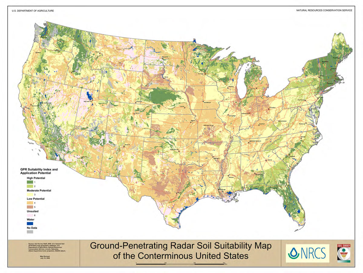
In this map from the U.S. Department of Agriculture, we can see the different GPR Suitability Index and Application Potential Across the Nation
Northeast — Boston, New York, Philadelphia, Portland
The Northeast region presents challenging but manageable conditions for Ground Penetrating Radar (GPR) utility locating due to its mix of glacial tills, bedrock outcrops, and complex urban fill materials. In major cities, underground environments often include multiple generations of utilities and engineered backfill, which can make subsurface detection more complex.
Overall, expect moderate GPR performance. High-frequency antennas are effective for detecting shallow utilities in dry conditions, but clay pockets and saturated soils can reduce signal depth and clarity. To improve results in subsurface utility engineering (SUE) projects, it’s best to combine GPR with electromagnetic (EM) locators, review historical utility records, and schedule field work during drier seasons. Proper velocity calibration on known targets and tight cross-line spacing also help improve accuracy in mixed ground conditions.
GPR survey tips from Safe Site (Northeast Regions):
- Use 900–2700 MHz antennas for high-resolution shallow utility locating in dense urban areas.
- Combine GPR with EM locating and vacuum excavation for accurate utility verification.
- Avoid conducting surveys right after heavy rainfall to reduce soil moisture interference and improve data quality.
Southeast — Miami, Jacksonville, Atlanta, Birmingham
The Southeast region shows a clear transition from coastal sandy soils to inland red clay, and these ground conditions directly affect geophysical surveys like GPR. Coastal sands typically offer excellent radar penetration when they are dry, while inland clay soils and high groundwater levels can significantly reduce signal depth and clarity. In addition, seasonal storms and hurricanes can quickly change soil moisture, which impacts survey accuracy and planning.
Actionable tips from Safe Site for better survey results:
- Prioritize coastal sands for deeper GPR surveys: coastal areas usually deliver strong results, especially during dry seasons when sand is less saturated and more stable.
- Adjust methods in clay-heavy zones: in red clay regions, reduce grid spacing for higher resolution and combine GPR with sondes or vacuum excavation to confirm utility locations.
- Plan around weather and moisture changes: whenever possible, avoid hurricane season for coastal projects and always document recent rainfall to better interpret subsurface conditions.
By matching your survey approach to these regional soil and weather conditions, you can improve accuracy, reduce risks, and achieve more reliable utility detection results.
Midwest — Chicago, Cleveland, Minneapolis, Des Moines
The Midwest region features predominantly clay-rich soils that are heavily influenced by seasonal moisture changes and repeated freeze–thaw cycles. In many urban areas, older industrial fill and disturbed ground further increase subsurface complexity. As a result, GPR performance is typically moderate for shallow utilities, but depth and clarity can become limited after heavy rainfall or during spring thaw conditions.
Actionable tips by Safe Site for better survey results:
- Time surveys for drier soil conditions: plan fieldwork for late summer or early fall when soils are typically drier and more stable, improving signal clarity and depth.
- Adjust frequency based on target depth: use higher-frequency antennas for precise shallow utility locating, but set expectations for reduced depth penetration in clay-heavy environments.
- Validate with ground truthing methods: combine GPR with physical verification methods to improve accuracy, especially for agricultural drainage systems and complex utility networks.
By aligning survey timing and equipment strategy with Midwest soil behavior, you can improve detection reliability and reduce uncertainty in challenging subsurface conditions.
Plains and Mountain States — Denver, Billings, Omaha
Dry sands, gravels, and rocky terrains generally provide some of the best conditions for GPR, delivering strong depth penetration and clear subsurface imaging. However, in mining districts or areas with highly mineralized soils, signal distortion can occur. Hardpan and caliche layers can also reflect or block signals, making interpretation more challenging and requiring careful data analysis.
Actionable tips by Safe Site for better survey results
- Use low-frequency antennas for deeper targets: lower frequencies improve penetration depth and are better suited for regional or geological-scale mapping.
- Identify caliche and hardpan layers early: mapping these horizons first helps you understand signal boundaries and improves overall interpretation accuracy.
- Combine methods in mineralized zones: pair GPR with borehole logs or electrical resistivity surveys to confirm findings and improve confidence in complex soils.
By adapting your approach to soil composition and subsurface conditions, you can significantly improve accuracy in both geological and engineering applications.
Southwest — Phoenix, Tucson, Las Vegas, Salt Lake City
The Southwest region benefits from highly GPR-friendly conditions due to its arid climate and extensive dry desert soils. These dry sands allow for strong signal penetration and clear subsurface imaging. However, caliche layers and saline playa deposits can locally reduce depth performance and create reflective barriers that complicate interpretation.
Actionable tips for better survey results by Safe Site:
- Use multiple frequencies for detailed investigations: combining different antenna frequencies improves both shallow resolution and deeper stratigraphic understanding, especially in archaeological surveys.
- Identify caliche horizons early: mapping caliche layers helps set realistic depth expectations and prevents misinterpretation of signal loss as voids or targets.
- Leverage excellent shallow detection in dry conditions: take advantage of ideal desert conditions for locating shallow utilities and archaeological features, where GPR performance is typically strongest.
By tailoring survey strategies to desert soil conditions, you can achieve highly accurate results while minimizing uncertainty from natural subsurface layering.
West Coast and Pacific Northwest — Los Angeles, San Francisco, Seattle, Portland
The Pacific Northwest region features highly diverse geology, including volcanic deposits, coastal sands, clay-rich soils, and dense urban infrastructure. This variability directly impacts GPR (Ground Penetrating Radar) performance. In coastal and forested zones, high moisture and clay content can significantly reduce signal penetration, while volcanic rock tends to scatter radar energy and limit clarity.
Safe Site actionable tips for better survey results:
- Schedule surveys during drier months in wet coastal cities: in areas like Seattle and Portland, plan fieldwork outside the wet season to improve signal penetration and reduce soil saturation effects.
- Combine GPR with complementary geophysical methods: in saturated or clay-heavy soils, use resistivity or magnetic surveys alongside GPR to improve subsurface utility locating and increase interpretation accuracy.
- Adapt strategies for volcanic terrains: in areas with volcanic geology, collect data using multiple frequencies and rely on experienced interpreters to separate signal noise from real subsurface features.
By tailoring your survey approach to the Pacific Northwest’s complex geology and moisture conditions, you can improve reliability, reduce uncertainty, and achieve more accurate subsurface mapping results.
Alaska and Hawaii — Anchorage, Arctic regions, Honolulu
Alaska and Hawaii present two very different but equally challenging environments for GPR (Ground Penetrating Radar). In Alaska, permafrost can transmit radar signals very effectively when fully frozen, allowing for strong imaging conditions. However, seasonal thaw layers and ice lenses introduce complex signal reflections that can make interpretation difficult. In contrast, Hawaii’s basaltic and volcanic soils tend to scatter radar energy, significantly limiting depth penetration and overall clarity.
Actionable tips for better survey results by Safe Site:
- Use specialized equipment and experienced interpretation: in both permafrost and volcanic environments, select appropriate antennas and rely on experienced analysts to distinguish real targets from signal noise.
- Plan for remote and challenging field conditions: locations such as Anchorage and Honolulu often require additional planning for logistics, access, and permitting due to terrain and remoteness.
By adapting equipment, interpretation methods, and field logistics to these extreme environments, you can improve data reliability and achieve more accurate subsurface insights despite challenging ground conditions.
Pre survey planning and desk research
Good fieldwork in Ground Penetrating Radar (GPR) projects doesn’t start in the field; it starts with solid preparation at the desk.
A structured pre-survey process helps reduce uncertainty, improve data quality, and produce more reliable subsurface results across different soil conditions in the United States.
Here’s a practical workflow to guide your planning:
Collect background information
Begin by assembling all available site intelligence. This includes USDA Web Soil Survey data, local geotechnical reports, historical utility maps, as-built drawings, and recent aerial imagery. Don’t forget to review municipal permitting requirements and note any known or visible utilities. This step helps build a clearer picture of what may be present underground.
Analyze weather and groundwater conditions
Soil moisture plays a major role in GPR performance. Review recent rainfall, seasonal groundwater behavior, and irrigation activity. Sites with saturated soils, shallow groundwater, or recent flooding often show reduced radar penetration and increased signal attenuation, which is especially important to consider across varied U.S. soil types.
Evaluate site access and safety risks
Next, assess how the fieldwork will be conducted safely and efficiently. Identify traffic control requirements, confined space concerns, and other site-specific hazards. Confirm access points, permitting needs, and utility notification requirements ahead of time to avoid delays once on site.
Choose appropriate equipment
Select antenna frequencies based on expected target depth and size. In most cases, carrying a combination of equipment is best practice (typically a high-frequency antenna for shallow utilities and a mid- to low-frequency antenna for deeper investigatio). Supporting tools like electromagnetic (EM) locators and sondes should also be included to enhance accuracy and verification.
Align expectations with the client
Clear communication is essential. Explain how soil conditions, moisture content, and target characteristics influence both depth penetration and resolution in GPR surveys. Make sure limitations are understood and that excavation or other verification methods are clearly defined when required.
A well-prepared plan like this helps ensure smoother field operations, more dependable subsurface interpretations, and stronger overall project outcomes in a wide range of geotechnical environments.
Field workflow and data collection best practices
A disciplined field workflow is key to improving Ground Penetrating Radar (GPR) data quality and minimizing ambiguity during interpretation. Consistency in setup, data collection, and documentation leads to more reliable subsurface utility mapping results.
Here’s a clear, practical structure for field execution:
Pre-survey setup
Before data collection begins, ensure the system is properly calibrated and the site is fully prepared.
- Calibrate velocity using known targets such as manholes, exposed utilities, or sondes.
- Establish a coordinate control system using GPS or RTK for accurate spatial positioning.
- Lay out grid lines and mark control points to maintain consistent coverage across the survey area.
Data collection
Careful data acquisition is essential for high-quality results, especially in variable soil conditions.
- Run initial test lines to evaluate signal penetration and background noise levels.
- Use multiple antenna frequencies when available to capture both shallow and deeper targets.
- Increase line density in areas with heterogeneous or noisy soils for better resolution.
- Record site conditions such as soil moisture, recent rainfall, temperature, and groundwater observations.
- Collect cross lines and perpendicular grids to help confirm and validate linear utility features.
Verification
Field validation strengthens confidence in interpreted results and reduces risk.
- Use sondes for locating non-metallic utilities and electromagnetic (EM) locators for metallic lines.
- Where critical targets are identified, confirm findings through vacuum excavation or test pits.
- Document all verification work with photos, GPS coordinates, and measured depths for traceability.
Field notes and metadata
Accurate records are just as important as the survey data itself.
- Log antenna type, system settings (including gain), operator name, time of survey, and any field anomalies.
- Store raw data and processed files with clear, consistent naming conventions to support later review and reporting.
A structured approach like this helps ensure cleaner datasets, more confident interpretation, and stronger overall reliability in GPR and utility detection projects.
Processing and Interpreting GPR Data Across Different U.S. Soil Conditions
In Ground Penetrating Radar (GPR), data processing and interpretation turn raw radar signals into clear, usable maps of what lies beneath the surface. Across different U.S. soil conditions, this step is especially important because clay content, moisture, and ground variability can strongly affect signal quality. While software plays a major role, experienced interpretation remains essential for accurate results.
First, technicians apply time zero correction and remove background noise to clean up the raw radargram and properly align the signal. Next, they use bandpass filtering to reduce unwanted frequencies and improve overall clarity. Then, they apply migration to correct distorted reflections and collapse dipping features, which improves the spatial accuracy of underground targets. Finally, they generate time slices and 3D volume models to support clearer plan-view mapping and interpretation.
After processing, interpretation focuses on building confidence in what the data shows. Technicians calibrate depth using known targets and measured velocities, especially in varying soil conditions found across the U.S. In addition, they correlate anomalies across multiple survey lines and cross lines to confirm whether a feature is continuous. They also classify targets by analyzing amplitude, shape, and reflection continuity, which helps distinguish utilities, point targets, and potential voids. To improve accuracy even further, they combine GPR results with electromagnetic (EM) data, resistivity surveys, and historical utility records.
However, field data often includes artifacts that can affect interpretation. That’s why having a team of experts is essential for having the job done correctly.
Essential GPR Equipment, Software Tools, and Field Safety Best Practices
Successful GPR surveys across diverse U.S. soil conditions depend on the right combination of equipment, software tools, and safety practices. When teams prepare properly, they improve data quality, reduce field delays, and increase interpretation confidence.
To begin with, field teams use a GPR unit equipped with multiple antennas, typically ranging from 100 to 2700 MHz, to handle both shallow and deep targets. They also rely on electromagnetic (EM) locators and sonde systems to detect metallic and non-metallic utilities. In addition, they use GPS or RTK systems to ensure accurate positioning and mapping. A rugged data-logging laptop with processing software allows teams to review and process data in real time. Moreover, they bring ground coupling aids, antenna protection covers, and soft-dig tools such as vacuum excavation kits to support verification. Finally, they always include proper PPE and traffic control equipment to maintain field safety.
On the software side, technicians rely on tools that help improve clarity and allow better interpretation of complex subsurface conditions. Furthermore, amplitude analysis and annotation tools support detailed review, while GIS export capabilities allow seamless integration into client mapping systems and deliverables.
Safety and compliance guide every GPR project. Teams follow local utility notification laws and safe digging practices before excavation. They verify critical targets using vacuum or hand digging, apply traffic control and PPE in high-risk areas, and document all verification steps to ensure accuracy and regulatory compliance.
COnclusion and next steps
Ground Penetrating Radar (GPR) is a powerful, non-invasive tool for imaging what lies beneath the surface, but its performance always depends on local soil conditions. Across the United States, factors like clay content, moisture levels, and groundwater depth can significantly influence how well radar energy penetrates the ground and how clearly subsurface features appear.
Because of this, no single “one-size-fits-all” approach works for every site. Instead, successful GPR surveys combine proper planning, the right equipment, and strong interpretation skills tailored to each environment. In sandy, dry soils, GPR often delivers deeper and clearer results, while in clay-rich or highly saturated soils, signal attenuation can limit depth and resolution.
Even so, when technicians properly account for soil conditions and integrate GPR with other locating methods like electromagnetic (EM) detection and historical records, it becomes a highly reliable solution for utility mapping, geotechnical investigations, and construction planning.
Ultimately, understanding how soil conditions affect GPR performance is the key to producing accurate, dependable subsurface data and reducing risk on projects across all regions of the U.S.
Choose Safe Site for Professional GPR Services
For accurate, field-tested results, Safe Site provides expert Ground Penetrating Radar (GPR) services tailored to complex and variable soil conditions. Our team combines advanced equipment, proven field methods, and detailed interpretation to deliver reliable subsurface insights that support safer and more efficient project planning.